You see “deepwater access” on a Johns Island listing and picture leaving the dock at any tide, in any season, with no stress. That is the goal, but not every waterfront parcel delivers it the same way. The truth comes down to depth at low tide, the route to a maintained channel, and bridge clearance along the way.
In this guide, you’ll learn what “deepwater” really means on Johns Island, how it affects boat size and dock design, and the due diligence that protects your purchase and lifestyle. You will also see how the Stono side and the Wadmalaw side differ in practice. Let’s dive in.
Deepwater, defined for Johns Island
“Deepwater” is not a legal label. It is a market term that signals reliable navigation for larger boats without frequent grounding. On Johns Island, the standard you care about is depth measured at Mean Lower Low Water (MLLW) or Mean Low Water (MLW). Depths at low tide are the limiting factor for access.
Focus on three things:
- Low‑tide depth: Ask for MLLW or MLW soundings taken at the end of the dock and along the route to the channel.
- Channel access: A marked or maintained navigation channel usually holds more water than nearby creeks or slips. Your route matters as much as the depth at your dock.
- Vertical clearance: Fixed bridges are measured at Mean High Water. If a bridge reads 15 feet, many sailboats will not pass at high tide.
As rules of thumb, “shallow” water often means less than 3 to 4 feet at MLW. “Marginal” deepwater is roughly 3 to 6 feet at MLW and can suit smaller center consoles and bay boats. Many buyers use “true deepwater” to mean 6 feet or more at MLW with maintained channel access. If you plan for a larger yacht or deep‑keel sailboat, you may want 8 feet or more at MLW, depending on draft and safety clearance.
Boat size and safe depth
Your boat’s draft drives your minimum depth. Also consider load, trim when running, and propeller depth. Most owners add a safety margin under the keel.
Typical drafts for common boats:
- Small skiffs and tenders: about 1 to 2 feet
- Center consoles and dual consoles: about 1.5 to 3 feet
- Express cruisers and pilothouse boats: about 3 to 5 feet
- Trawlers, large motor yachts, deep‑keel sailboats: 5 to 9+ feet
A practical approach: add 1 to 2 feet of underkeel clearance for smaller powerboats and 2 to 4 or more for larger or displacement craft. If you want to keep a 40 to 50 foot yacht or a full‑keel sailboat at home on Johns Island, target documented depths of 6 to 9 feet or more at MLLW and confirm reliable channel maintenance along the route.
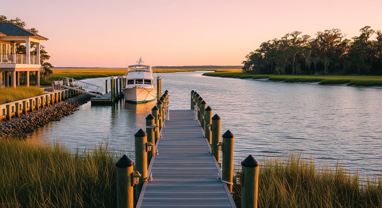
Docks, layout and end‑of‑dock depth
Dock design follows depth. Where low‑tide water sits farther from shore, docks are often longer to reach adequate depth year‑round. Berth length should exceed your boat’s overall length to allow fendering and safe access.
Common configurations:
- Fixed pile docks work well where water is consistently deep and tidal swing is moderate.
- Floating docks adapt to tidal range and are paired with pile guides.
- Finger piers and slips add side‑tie options but need room to maneuver.
- Boat lifts can help in marginal depths by hoisting the boat clear when parked. Lifts require structural and electrical planning.
Many owners aim to keep keels clear of the bottom at MLW with a margin. That may require docks 50 to 150 feet or more, depending on the lot and local shoaling. A local dock builder or coastal engineer can estimate length, piling depth, and lift specs for your exact site.
Bridge clearance and route planning
Depth is only part of the story. Vertical clearance can be the stopper. Fixed bridges list clearance at Mean High Water. Movable bridges open on schedules that affect timing. Mast height, antennas, and hardtops all matter.
Before you buy, map the entire route from the dock to Charleston Harbor. Note every fixed crossing and any tight bends in narrow creeks. Larger vessels may need to plan transits around tide and current in these pinch points. The safest plan is to confirm actual clearances and run the route at different tides with a local captain.
Stono side vs. Wadmalaw side
Johns Island touches several tidal systems. In broad terms, parcels facing the Stono River often offer more direct runs to Charleston Harbor with sections of deeper, maintained channels and shorter transit times. Many boaters appreciate the more straightforward navigation here.
Parcels on the Wadmalaw side connect to the Wadmalaw River, Bohicket, and smaller creeks. Some tracts are genuinely deep, but others are narrow or more prone to shoaling and tidal restriction. You can find excellent water in select creeks and also find soft spots that change with storms or seasons.
The key is that conditions are parcel‑specific. Two neighbors on the same creek can have different experiences based on a dock’s reach to the channel and where shoals form. Treat each property as a one‑off and verify depth, route and sediment patterns rather than relying on neighborhood generalities.
Tides, shoaling and maintenance
Johns Island is tidal, and flats move. A single depth number is not enough. Shoaling can change over months or years. Soundings from last season may not reflect today.
Check for a history of dredging in the route you plan to use. Public channels may receive periodic maintenance. Private channels and slips usually depend on owners or an HOA to plan and fund dredging. Ask for records of past work, permits, and known shoaling trends.
If your route runs through a private or unmarked area, budget for future dredging and watch for recorded easements that allow it. Without access rights and permits, you may not be able to maintain the water you need.
Permits, shoreline rules and risk
You will need approvals to build or modify docks, lifts, bulkheads and dredging. In South Carolina, coastal projects run through state coastal permitting and often federal review, with local county oversight for setbacks and lengths. Expect attention to marsh buffers, critical saltmarsh, and habitat protection.
Waterfront parcels can also sit in FEMA flood zones with higher building requirements and insurance costs. Check the latest Flood Insurance Rate Maps and Base Flood Elevations for structures on the lot and for any accessory buildings.
Before you offer, ask for copies of all dock and dredge permits, including any that have expired. Confirm whether the property benefits from community easements, recorded channel maintenance obligations, or restrictions that cap dock length, piling type, lighting, or lifts.
Everyday use, costs and value
Depth affects daily life. If water is shallow at low tide, you will plan departures and returns around the clock. Strong tidal currents in narrow creeks can make docking tricky and may require more experience at the helm.
Ownership costs add up. Private dredging can be significant over time. Docks, lifts and electrical systems face saltwater wear. Insurance premiums can increase with storm surge exposure and wave action.
For resale, properties with documented year‑round deepwater access, maintained channel routes, and shorter runs to the harbor tend to command premiums among boat‑dependent buyers. Listings that claim “deepwater” without records often face more questions and longer diligence.
Buyer due diligence checklist
Do not accept marketing language at face value. Verify, document, and stress‑test the route you plan to use.
Key documents to request
- Low‑tide soundings: Recent measurements at MLLW or MLW at the dock and along the approach, signed by a licensed marine surveyor.
- Channel maintenance history: Records of public maintenance or private dredging permits and invoices for the past 5 to 10 years.
- Permits and plans: All dock, lift, pier, and dredge permits for the property, plus any expired permits.
- Navigation context: Written statement on whether the dock sits in a marked or maintained channel versus a private slip or side creek.
- Easements and covenants: Any recorded rights or restrictions related to channel use, dredging, or dock length.
- Bridge data: A list of fixed bridges on the route, with clearances measured at Mean High Water.
- Insurance history: Past claims related to the dock, shoreline structures, or flood.
Questions to ask
- What is the depth at the end of the dock at MLLW?
- Is the approach within a maintained channel? If not, who pays for dredging and how often has it been done?
- Are there easements that limit access, dredging, or dock length?
- Have recent storms changed depth or channel configuration near the property?
- Are there local rules from the county or HOA that limit dock or lift design?
- Are there underwater obstructions, cables, or oyster leases nearby?
- What is the typical transit time to Charleston Harbor, and what fixed bridges are along that route?
Pros you will want on your side
- Licensed marine surveyor or local captain to run soundings at low and mid tide along the route.
- Licensed land surveyor to confirm boundaries, hydrographic data, and riparian rights.
- Coastal engineer or trusted dock builder to determine dock length, piling depth, and lift capacity.
- Real estate attorney or title company to pull easements, covenants, and maintenance obligations.
- Local permitting contacts to review state and county requirements before you invest.
Work with a local advisor
Waterfront on Johns Island can be extraordinary, but the best outcomes come when you match the property to your boat and your routine. With the right due diligence, you get year‑round access, fewer surprises, and a better resale story.
If you are weighing Stono versus Wadmalaw, testing draft for a specific vessel, or assessing dock length and lift options, let’s talk through it. We can coordinate the right surveyors and contractors, review permits, and plan the safest, most convenient route to the harbor. For confidential guidance and a tailored search, connect with Tricia Peterson.
FAQs
What does “true deepwater” mean on Johns Island?
- Many buyers look for 6 feet or more at MLW, with a maintained channel route. For larger yachts or deep‑keel sailboats, 8+ feet at MLW is a common target.
How big a boat can I keep at a Johns Island home?
- Match depth to draft with safety clearance. A 40 to 50 foot yacht often needs 6 to 9+ feet at MLLW and dependable channel maintenance to run reliably year‑round.
How do bridge clearances affect my route to Charleston Harbor?
- Fixed bridge clearances are measured at Mean High Water. Compare your air draft to those numbers and plan timing if a movable bridge or tight creek is on your route.
How long should my dock be to reach deepwater?
- It depends on the lot and bottom profile. Many owners need 50 to 150+ feet to reach adequate low‑tide depth, confirmed by recent soundings and a dock builder’s plan.
Who pays for dredging if my approach is not maintained by the state?
- Private channels and slips are typically the responsibility of owners or an HOA. Ask for records of past dredging, permits, and any covenants that share costs or restrict work.